
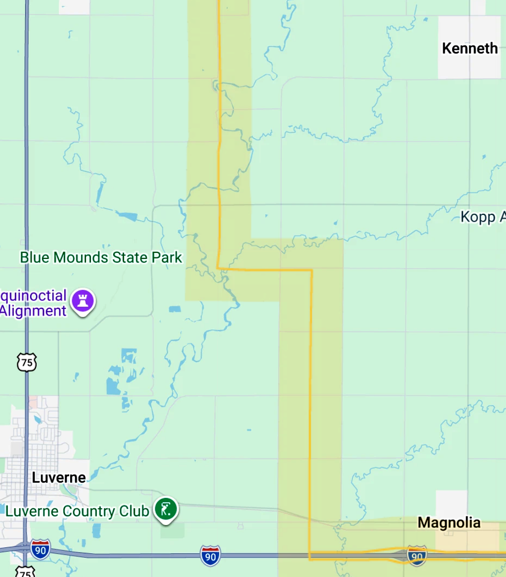
PowerOn Midwest has narrowed its preferred route for a proposed high-voltage transmission project, and one of its choices would cut through Rock County within one mile of the Blue Mounds State Park.
At an open house event in Luverne on Aug. 5, route maps were on display showing a proposed 765-kilovolt transmission line between substations in Brookings, S.D., and Lakefield, Minn.
The project is a collaboration of Great River Energy, ITC Midwest and Xcel Energy, which are also planning route segments to Rochester and the Twin Cities.
The current preferred transmission route cuts diagonally from Brookings to Lakefield, skipping Rock County entirely.
But if that isn’t approved, an alternate route would go south through Rock County on its way to Interstate 90. That route would be west of Kenneth and east of Luverne, between the state park and the Rock River.
“The routes down here in Rock County are alternative routes,” said Rod Pritchard, a marketing and communications manager with ITC Midwest.
“The Minnesota Public Utilities Commission ultimately determines the route.”
If the project is approved, the MPUC will be presented with a primary route and alternative routes by PowerOn Midwest. Then, after public hearings on the routes, it will decide which one is best suited for the project.
Meanwhile landowners and other concerned parties can communicate directly with PowerOn Midwest officials to refine their routes.
That’s a part of how two previously considered routes in Rock County were dropped as alternatives.
“We encourage comments,” Pritchard said. “As we continue to refine the routes, we consider all of the comments, questions and input we receive. That’s what’s informed the refinement of the routes we have so far.”
Comments can be left on a map provided on PowerOn Midwest’s website, www.poweronmidwest.com/routing-process.
Concerns for Blue Mounds State Park
The structures carrying the 765 kV transmission lines would require 250 feet of right of way (125 ft each side from the centerline).
They’d be spaced 1,200 to 1,400 feet apart, roughly five structures every mile.
They are up to 175 feet tall with wire carriage at the top spanning up to 145 feet across. The footprint of the base is roughly 50 by 50 feet with a foundation nearly 65 feet deep.
Aaron Mielke, a routing specialist with the project, said PowerOn Midwest has been communicating with the Minnesota Department of Natural Resources about potential impact on state parks.
“We’ve met with the Minnesota DNR and the state historical preservation office and are working with them on our routing (and) what their preferences are,” Mielke said.
Haley Byron, an environmental assessment ecologist with the DNR, shared some of the organization’s concerns with the proposed Rock County route with the Star Herald.
“The primary concern in Rock County is the potential visual impact on Blue Mounds State Park and Rock River Wildlife Management Area,” Byron said.
“The DNR has requested that a visual impact study be completed for all state parks adjacent to the route.”
Impacts on the park’s vistas aren’t the only concern the DNR has raised.
“We do have concerns about riparian vegetation clearing in the right-of-way and impacts on wildlife that use waterways as travel corridors,” Byron continued.
“Maintaining the ecological integrity of riparian corridors is a priority for the DNR, and we’ll be working with the project proposers on measures to avoid, minimize and mitigate those impacts.”
Measures could include ways to reduce avian collisions with the towers and a vegetation management plan for the right-of-way.
Blue Mounds State Park is also home to a protected type of wetland, known as a calcareous fen. While it isn’t located directly on the proposed route, it could be affected by disruptions to the aquifer that the towers’ foundations might cause.
“A thorough hydrogeological assessment must be conducted to prevent an aquifer breach that could drain the fen,” Bryon said. “Fens are sensitive to changes in groundwater five-plus miles away.”
The DNR is continuing discussions with the companies behind PowerOn Midwest and has expressed its concerns in writing.
The results of the hydrogeological and visual assessments may impact the viability of the route, depending on their findings.
If the route is determined to impact the calcareous fen, the commissioner of the DNR could bar the route from consideration, or require a management plan.
The findings from these assessments could also motivate PowerOn Midwest to voluntarily remove the route through Rock County from its list of alternatives.
Public opinion
Opinions on the route from Rock County residents are mixed. While some support the project and its benefits to the electrical grid, others are concerned about the impact on the state park, landowners and more.
Ben Vander Kooi shared that he personally supports the project.
“As a citizen who lives on the other side of the park, I’m thrilled they went to the east of it and avoided Touch the Sky Prairie,” he said.
Regarding the potential visual impacts to the park, Vander Kooi isn’t overly concerned.
“They have to find a route, and that route will likely impact natural areas,” he said. “Do I think it’s a major problem here? No, I don’t.”
He sees the transmission lines as a benefit to the reliability of the electrical grid, and noted that much of the electricity going through them will come from renewable sources.
“I think we should encourage that,” Vander Kooi said. “As far as the towers and the need for this, I’m completely on board.”
Others, like Lori Ann Hallstrom, disagree.
“There’s really no benefit (of the PowerOn Midwest project) to the state of Minnesota,” she said, saying that much of the power will be used in states farther down the lines.
“The person who owns the land where a tower goes gets a one-time payment and that’s it, and if they have to, they’ll go into eminent domain to force it from you.”
PowerOn Midwest plans to purchase easements from landowners along the route, at a market rate, per-acre price that includes the area of the tower and its foundation, and the land beneath the power lines.
Farmers would still be able to plant crops or graze animals in between the towers and beneath the lines, but would not be allowed to build structures or plant trees.
The one-time payment to landowners will also include an amount per tower on their property, though representatives from PowerOn Midwest did not yet have a number for what that would be.
If negotiations with a landowner on the route fail, PowerOn Midwest will be able to use eminent domain to acquire the land and fair compensation would be decided after the fact by a judge.
“I would say we don’t need something like this cutting through the natural beauty of our state, and frankly, I don’t think the multi-billion-dollar corporations behind this are thinking about anything except for their bottom line,” Hallstrom said.
While local opinions vary, the project itself has yet to be approved, and opportunities to provide input are included throughout the multi-year process.
As the MPUC takes up approval for the project, public hearings are scheduled for early November across southern Minnesota regarding the certificate of need PowerOn Midwest requires to pursue the project.
A final application of proposed routes is expected to be submitted to the MPUC in February of 2027, and if the project goes through the lines wouldn’t be in service until 2032 or 2034.
Mielke said PowerOn Midwest welcomes comments from everyone who could be affected by the lines.
“If anybody is concerned with the route, whether it’s in regard to their own parcels or public property like the state park, we continue to invite comments,” he said.