


 ,
,  ,
,  ,
, 
Last year Father’s Day weekend celebrations were put on hold in Rock County as residents dealt with the aftereffects of severe flooding.
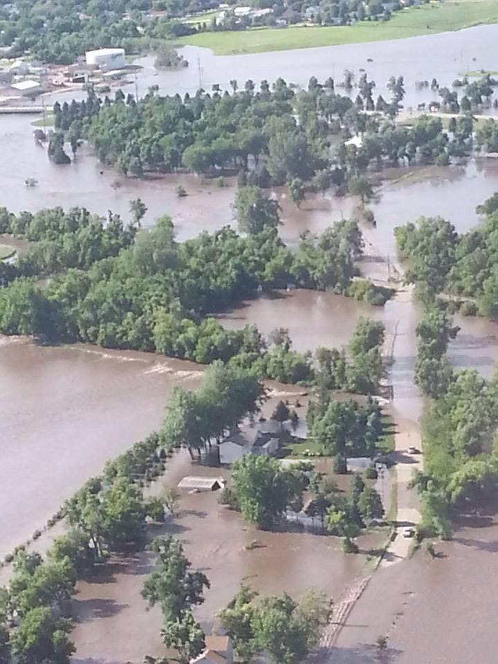
The persistent weather front helped the area recover from a yearlong drought, but it turned into too much of a good thing June 14-16, 2014, when more than 13 inches of rain caused the Rock River to swell to new record high levels.
No lives were lost, but Rock County suffered more than $4 million in public property damage, $4.8 million in damage to agricultural land and an untold amount of damage to private homes.
A year later, with the majority of property repaired, the Star Herald looks back to June 2014, the lessons learned and what may be coming in the future.
The rain prompts record crests on Rock River
During June 2014 volunteer weather recorder Troy Thone measured more than 13 inches of rain at Quentin Aanenson Airfield south of Luverne.
The 13.52 inches was 9.60 inches above normal and pushed the yearly rainfall total to 18.50 inches. That amount was 5.25 inches above normal yearly totals.
Thone noted that even more rain fell in the northern third of Rock County (possibly 20 inches or more) where a damaging June 16, 2014, hailstorm flattened crops, pocked homes with holes and shattered windows.
The sudden deluge of rain over a short period of time in northern Rock County was devastating to downstream entities that included the city of Luverne.
The National Weather Service (NWS) reported the Rock River crested on June 17, 2014, east of Hardwick at 21.18 feet, more than seven feet above flood stage and more than three feet above the previous high of 18.70 recorded on April 23, 2001.
At Luverne the NWS reported the Rock River crested at 16.85 feet on June 17, 2014, more than six feet over its flood stage of 10 feet.
At more than 16 feet, the new record was more than two feet above the previous high of 14.23 feet recorded on May 8, 1993.
Flood closes all but one river crossing in county
As the Rock River swelled, the Rock County Sheriff’s Office issued flood warnings through its nixle.com instant messaging system. Some residents, however, didn’t heed the warning.
Sheriff Evan Verbrugge said people didn’t think a flash flood could happen in a county that doesn’t have large bodies of water.
But flash floods can happen as he and Rock County residents found out on June 16, 2014.
“It was a long 18-hour day,” Verbrugge said.
Reports of motorists washed off roadways and residents trapped by floodwaters prompted requests for assistance from neighboring counties including a boat from Yellow Medicine County, Verbrugge said.
The Rock County Emergency Operations Committee opened a command center on June 16, 2014, at the Law Enforcement Center in Luverne to coordinate services and to assess damage, according to emergency management director Kyle Oldre.
“The county doesn’t seem that big until you need to have eyes in each area,” he said.
At one point there was only one east-west road crossing over the Rock River and that crossing changed as floodwaters began cresting further south, he said.
Township officials joined city and county officials to assess road damage, make emergency reports and to monitor weather reports to warn citizens of road closures and potential flash flooding dangers.
Force of water uprooted trees, rushed into structures
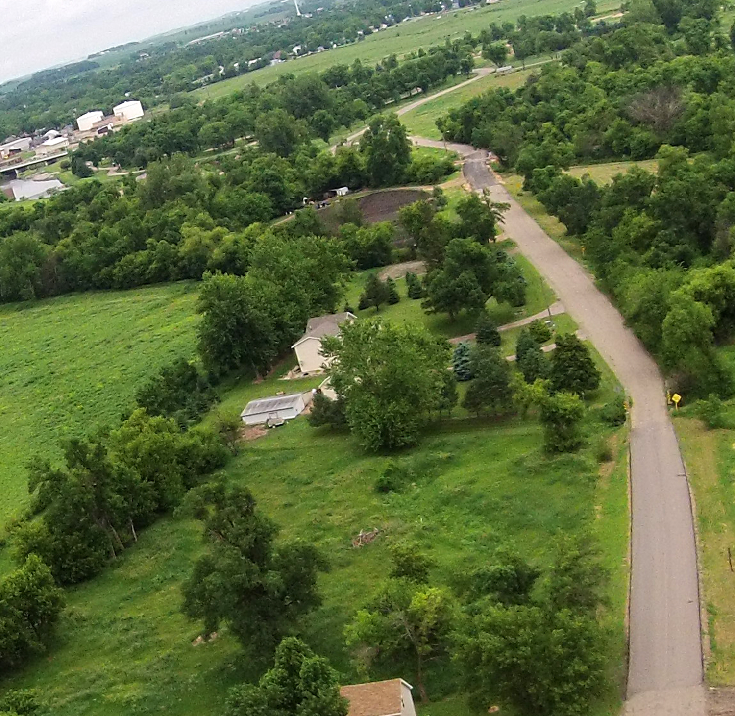
Karen and Mike Mensen have lived on Rock River Road east of Luverne for more than four decades.
“We have lived here for 45 years without seeing anything like that,” Karen Mensen said.
Nixle.com messages warned the couple who was out of town at the time about road closures. The messages prompted the couple to check on their home.
Located a half-mile from the river, Mensen said they were accustomed to flooding in their backyard but nothing to the extent they saw on June 15, 2014, when river water was rushing into the garage and uprooting mature evergreen trees.
“We were very fortunate no water came into the house,” she said.
With a sump pump keeping water levels in the unfinished basement low, the Mensens kept a round-the-clock watch as the river crested and subsided days later.
The debris left by the receding floodwaters filled four dump trucks.
“The smell for weeks was nasty,” she added.
The repairs continue, as do flood mitigation plans
Rock County and six other Minnesota communities qualified for a federal disaster declaration and release of federal aid to assist townships, cities and the county to make repairs.
Since then, the majority of the road repairs have been completed throughout Rock County, including the $1.5 million in damages to the Buffalo Ridge Railroad.
In Luverne, public damage estimated at $351,000 was limited to the city’s east side where the city park and the Redbird baseball field were hard hit.
City administrator John Call said engineers are considering a berm-like structure to limit future flood damage to the ball field.
“It (the structure) would keep trash and other debris in the river and not cause any more harm downstream,” he said about the project, which is only in the planning stages.
The city will work with county officials on improving the storm water flow on North Blue Mound Avenue near 131st Street to disperse water coming to the city from the north and west into nearby farmland, away from residential housing.
“Storms are coming more frequently,” Call said. “We need to plan for more water (events) in the future.”
Silver lining for wildlife
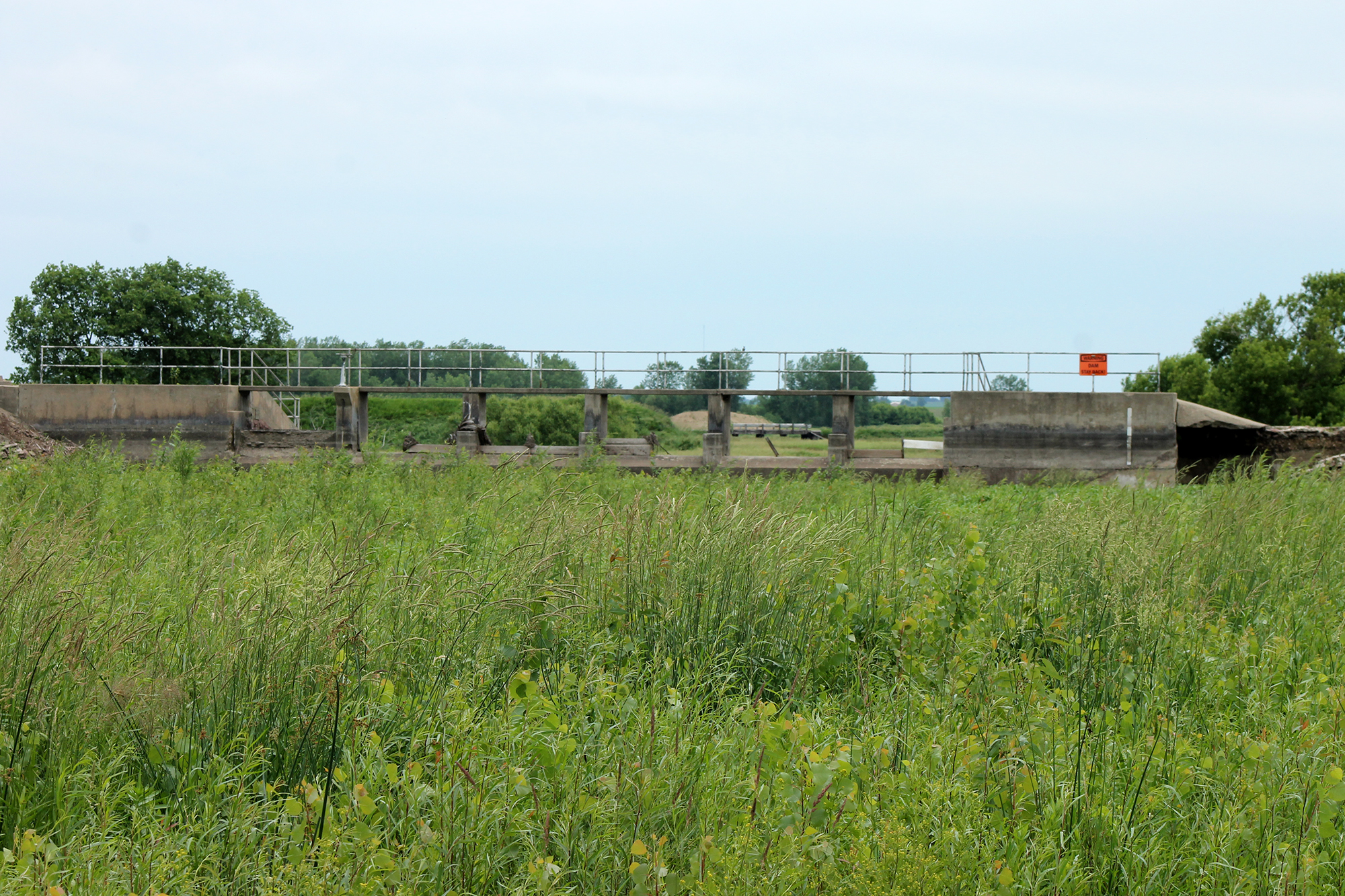
The Lower Mound Lake no longer exists at Blue Mounds State Park, a casualty of the strong currents that eroded portions of the dam.
While state and federal officials decide if or how the dam should be repaired and a lake formed again, visitors to the park are enjoying the change in migratory birds to the area.
“Shore birds we don’t normally see are here,” said park employee Kathy Deuschle. “These birds wouldn’t normally be around.”
Lower Mound Lake has been reduced to a grassy marsh, attracting birds to stop instead of going elsewhere. Excited birdwatchers have told Deuschle of the discovery.
Birds, such as Canada geese, who desire the solid surface of a lake, now stop at the park’s Upper Mound Lake.
The aftermath
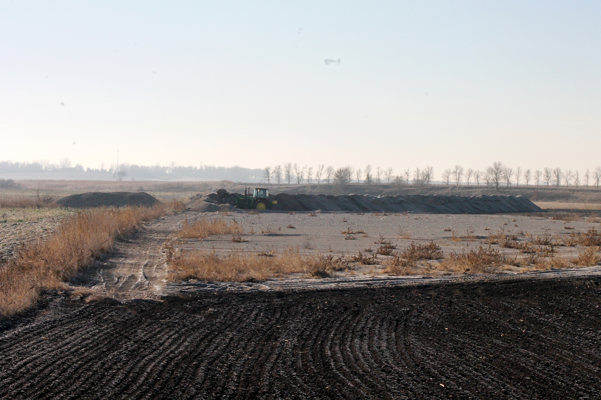
Last year more than 100,000 acres of farmland were damaged by floodwater and the hailstorm that pummeled the northern third of Rock County.
Fraser Norton, Rock County Farm Service Agency director, said the majority of the fence damage has been repaired and debris has been removed from farm fields.
“The effects of the last year are still being felt,” Norton said.
Many fields were washed of crop residue and a new crop needs to be planted and harvested in order for the residue to be replaced.
Norton said he is disappointed that more farmers didn’t take advantage of federal programs that could help with conservation repairs.
“They (area producers) are not in the mindset, if there is damage, to run to the government office to see what money is here,” Norton explained. “People roll up their sleeves and do it themselves.”
One of those who completed the work themselves is Hardwick farmer Hal Paulson. He spent time last fall scraping the sand and gravel deposited by floodwaters on his farm field on the west side of the Rock River.
“If you have a couple of inches you can incorporate it into the soil,” Paulson said.
He estimated four to five acres were covered with more than three feet of silt that needed to be removed before spring planting. Paulson scraped the silt into piles.
Besides flooding debris, Paulson said the field was hammered by hailstones reported to be as large as golf balls. Unable to replant, Paulsen left the rows to fend for themselves, and his corn harvest yielded only 20 bushels per acre. Normally his yield average is 150 bushels.
Crop and hail insurance covered the majority of the yield loss.
“It was good,” Paulson said of the coverage.
This year he has planted soybeans.
“It could flood (and hail) again, but that’s the way it goes,” he said.


