


Luverne City officials are working with engineers on a berm that would minimize flood damage at Redbird Field.
In the June 2014 flooding, a raging Rock River spilled its banks and deposited corn stalks, debris and tons of sand and silt onto Redbird Field.
After spending $200,000 to clean it up, the city looked for ways to reduce similar damage in the future.
Working with its city engineer, Gary Kurth of DGR, Rock Rapids, they came up with a plan that DNR hydrologists have signed off on.
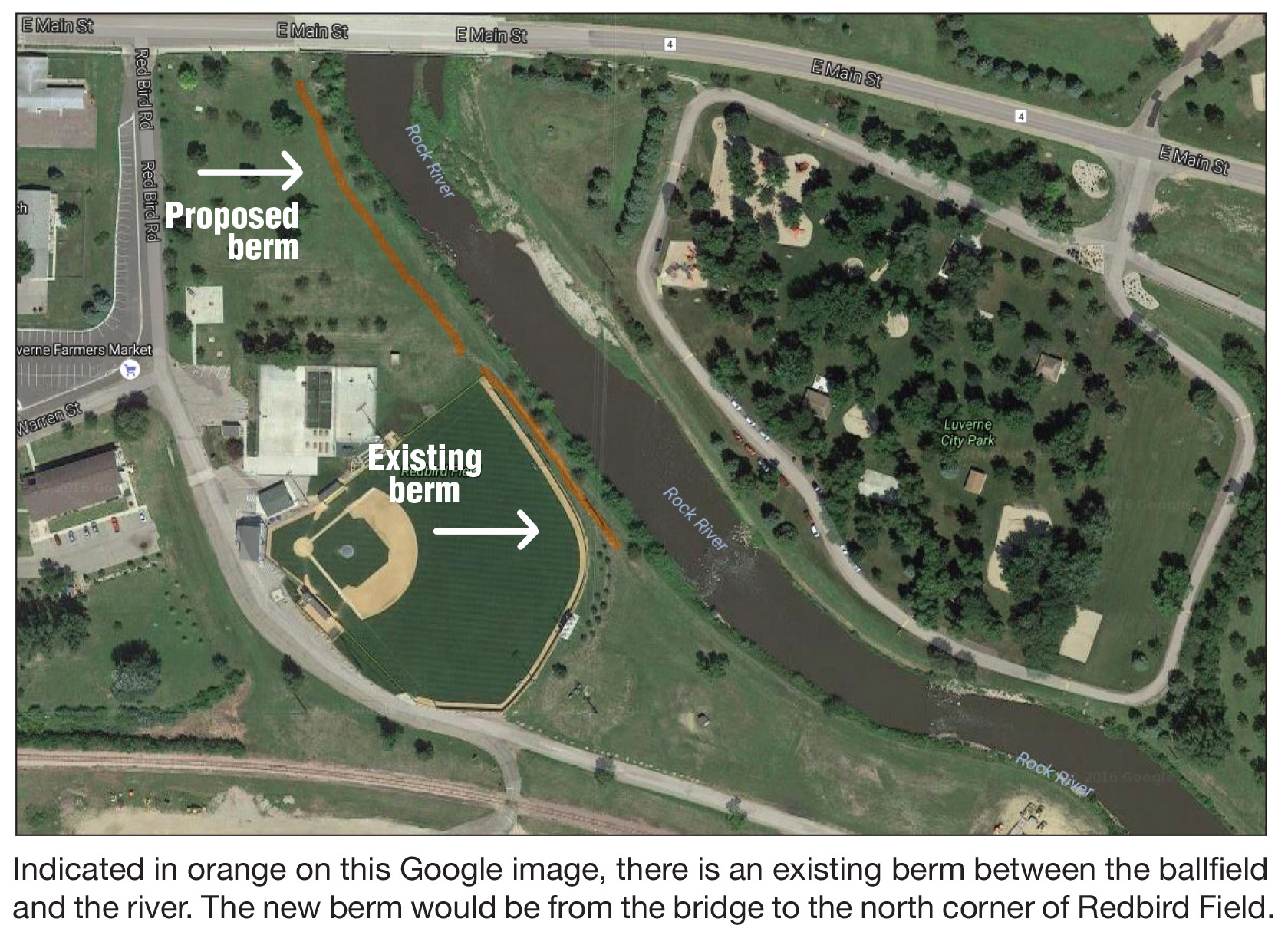
There is an existing berm that runs along the outfield of the ball diamond.
The proposal is a 4-foot-high earthen berm 450 feet long that extends from the Main Street bridge to the northeast corner of Redbird Field.
The estimated cost of the project is $55,000, and a state grant will cover most of that cost.
Both engineers and state hydrologists note that the berm won’t prevent flooding; water will still fill this area during floods. The goal is to divert water through the floodway in order to slow the rushing river and avoid the debris.
Downstream property owners Mike and Karen Mensen attended the Sept. 20 City Council meeting to express concern about how the berm would affect their property downstream.
“This is all about ball diamonds versus personal property,” they wrote in a letter that was also signed by their neighbors, Arne and Gloria Vink.
“We are opposed to this project and want that opposition to be public record.”
Hydrology and engineering studies have confirmed that the berm won’t affect river flow for properties downstream.
At the meeting Karen said she respects the opinion of the DNR and the council, but she wanted their concern noted for future city council and state officials.
“If you lived where we live, you would have the same concern,” she said.
“We have lived there 45 years and pumped our basement three times. Our house it built up, and we have a berm of our own.”
Mayor Pat Baustian noted the increasing frequency of significant rain events due to global warming.
“You may want to keep those pumps handy,” he said.
“Our flood in 1993 was considered a 100-year flood, but we’ve had five significant rain events since 2000.”
While questions linger about the berm’s impact downstream, the council is still left to consider future development in an area that is designated for flooding.
Most communities develop parks and ball diamonds in floodplains, because that’s the best use for that type of ground.
But in light of the trend toward “significant rain events,” the question appears to center on how much money a city should spend to develop these properties and clean them up after flooding.
According to Public Works Supervisor John Stoffel, the berm would prevent the $200,000 damage (that FEMA helped pay for) caused by the 2014 flood and possibly reduce cleanup costs to $100,000.
With plans in place to develop a Luverne Loop trailhead in the floodway next to Redbird Field, the Mensens and others are questioning the wisdom of those investments.
Trailhead cost estimates are $1.2 million, which includes parking, playground equipment, restrooms, shelter house, benches, waste receptacles and more. (The city has applied for a Legacy grant to support this project.)
A “regulatory floodway” is designated to take on floodwaters, according to local emergency management protocol.
This means “the channel of a river or other watercourse and the adjacent land areas must be reserved in order to discharge the base flood without cumulatively increasing the water surface elevation more than a designated height.”
It goes on to describe development of these areas.
“Communities must regulate development in these floodways to ensure that there are no increases in upstream flood elevations,” the statement reads.
“For streams and other watercourses where FEMA has provided Base Flood Elevations (BFEs), but no floodway has been designated, the community must review floodplain development on a case-by-case basis to ensure that increases in water surface elevations do not occur, or identify the need to adopt a floodway if adequate information is available.”
Grant money for the berm is available until December of 2017. “So we do have some time on it,” said City Administrator John Call.