


 ,
,  ,
, 
Construction will begin this summer on the third phase of Luverne’s Loop path, according to discussion at the Luverne Economic Development Authority meeting Monday morning.
EDA director Holly Sammons said a bid letting date has been set for March 4 and work will likely begin in June on the portion of the path that intersects at Main Street and Blue Mound Avenue.
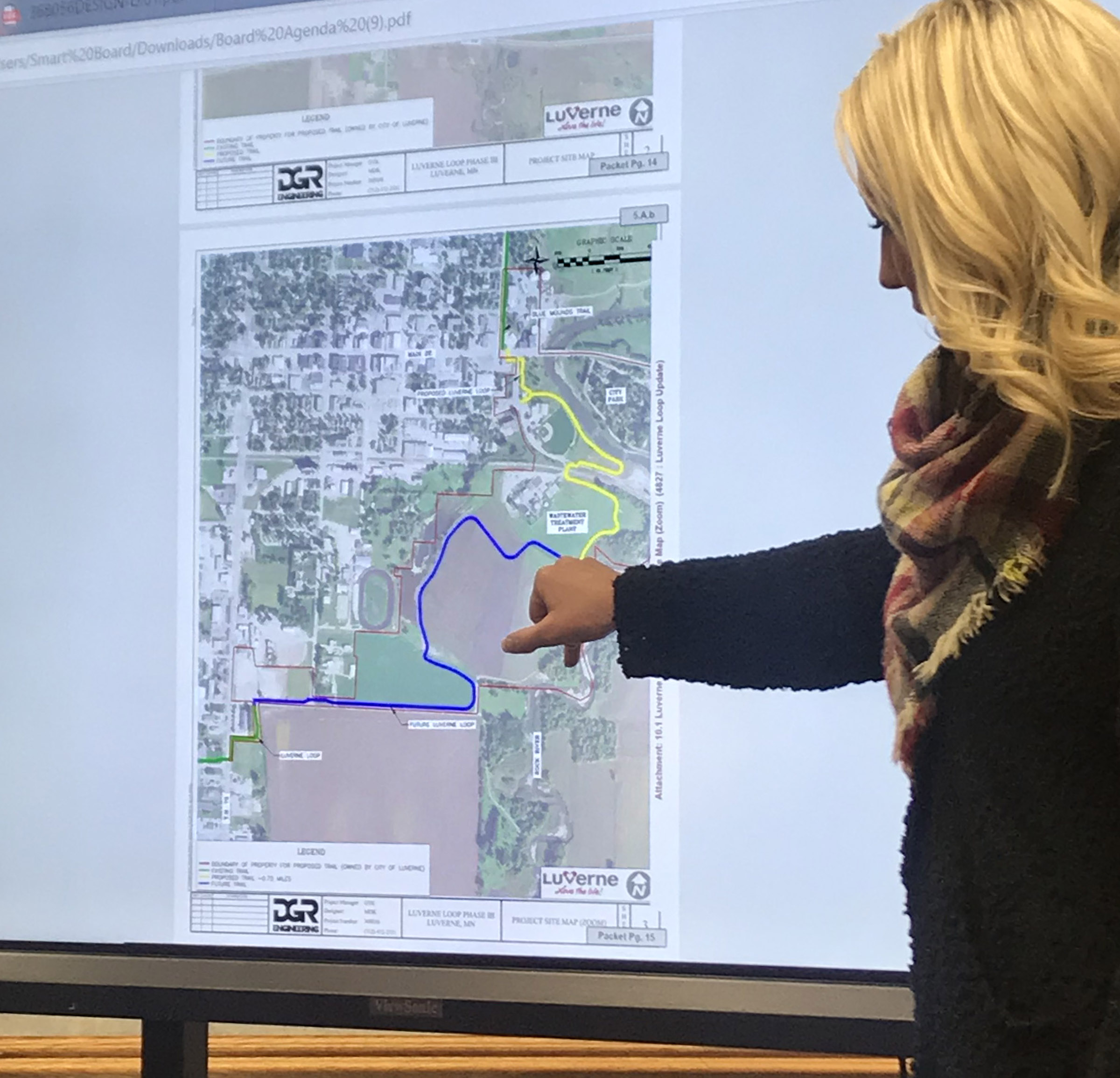
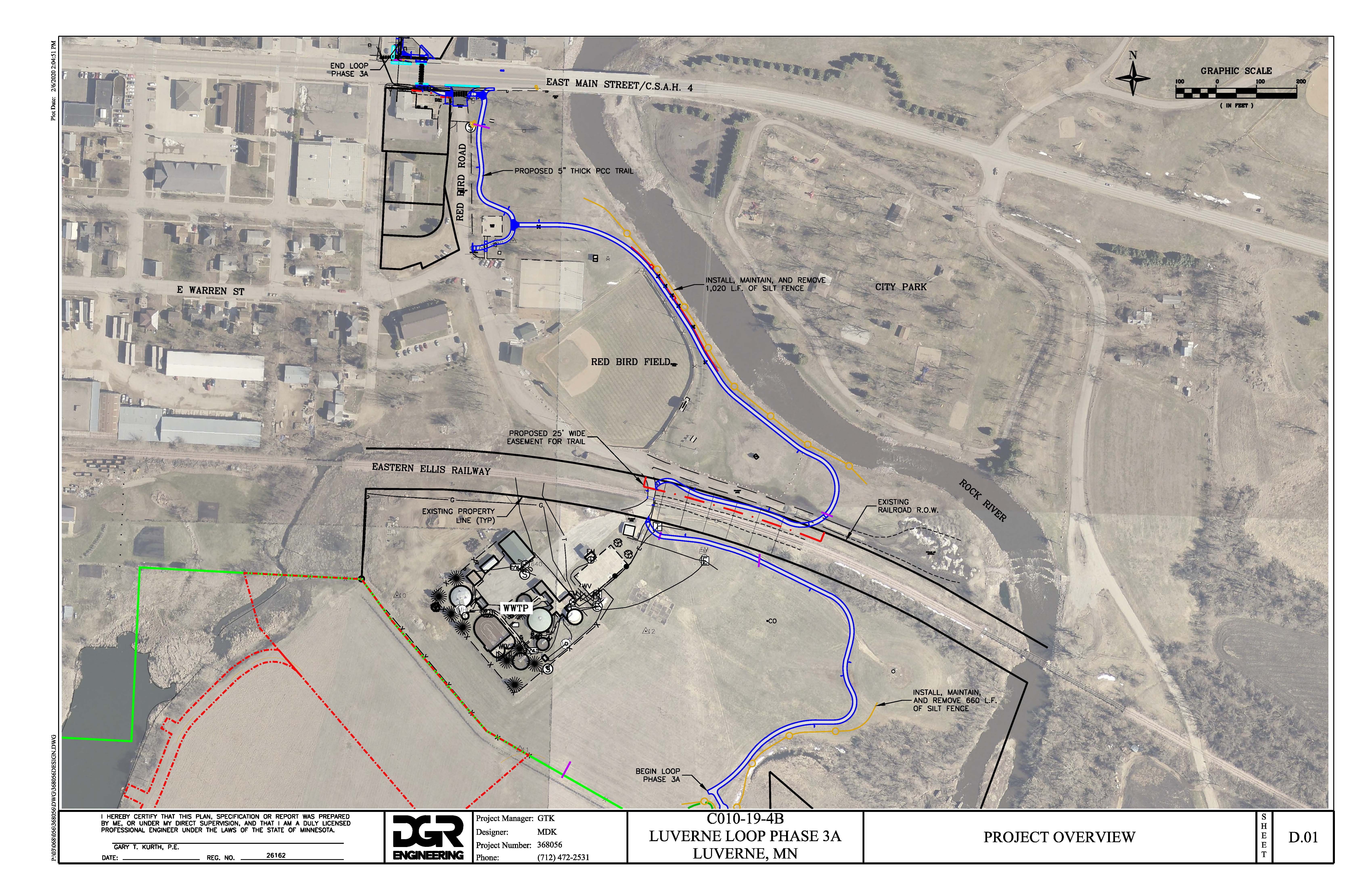
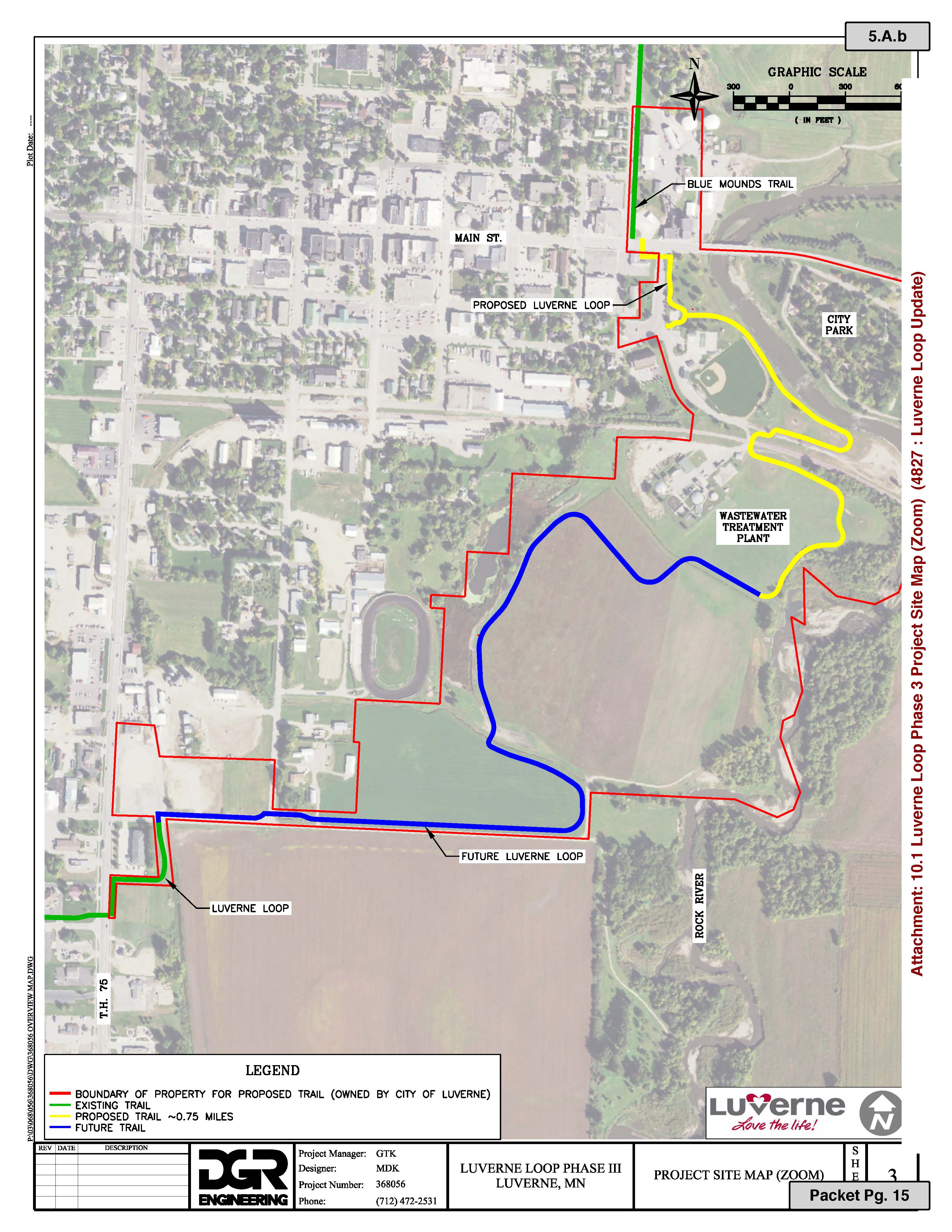
The next portion of the trail crosses East Main Street on the west side of the Rock River Bridge and follows the Redbird Field driveway and through green space between the backfield and the river.
“This area could be used for trailhead parking,” she said. “This at least offers two points of access from the north and south.”
The Loop will continue south and cross the railroad tracks. It will follow the south side of the tracks in green space around the base of the wellhead before it ends at an elbow near the Rock River.
“This is some nice green space that no one really knows about unless you happen to be down here,” Sammons said, pointing toward the area where the treated effluent from the wastewater treatment plant discharges into the river.
“It’s kind of a nice elbow in the river where you have a really good perspective for bird watching and for the water and we’re going to call this a rest point on the trail.”
Until the rest of Phase 3 is completed further south, this will also be the turnaround point for hikers and bicyclists.
“It will be its own little destination in itself,” Sammons said. “If you make it all the way out here to a dead end, you’re not going to be disappointed. It’s still a very pleasant view.”
Phase 3A plans and specifications are being finalized this week, bid opening will be the beginning of March, and after archeological clearance is granted, construction will start in June with completion expected possibly by October.
Phase 3A — about three-quarters of a mile — of the Loop is estimated to cost $584,000, which will be offset by a $150,000 Local Trail Connections grant.
Sammons said the final phase of Loop construction was divided into two parts because it’s the largest and costliest section of the overall 7-mile loop in town.
“We decided to split it in half and go for two grant opportunities,” she said.
Planning is underway for the final section of the trail yet to be completed. Staff is pursuing grant opportunities in hopes of securing some type of grant funding to assist in completion of the trail project.
Final leg of project will complete Loop at Hatting and Highway 75
The second part of Phase 3 will continue the trail southward through property the city purchased from Warren Baker, and it will connect with Hatting Street south of the fairgrounds before meeting at Highway 75 where Phase 2 of the Loop currently ends.
The Baker land was in a perpetual conservation easement, and the city petitioned the Board of Water and Soil Resources to release a five-acre segment of the easement.
Four acres were needed for the city’s wastewater treatment expansion and one acre is for the trail.
The 10-foot-wide trail has a 10-foot easement on each side, making it a 30-foot-wide corridor that comprises roughly one acre through the property that’s permanently enrolled in Reinvest in Minnesota.
“We’re going through the legal process right now with the BWSR Board, and once that is cleared it really opens up possibilities for grants for Phase 3B.
Sammons said she’s planning to apply for a large grant through the Minnesota Legacy Fund.
“It’s very competitive,” she said. “You have to be a trail of regional significance (the Loop has this designation) to qualify, and the feedback I’ve gotten is that they like to fund projects that are nearing completion.”
She said Legacy Funds can also be used for trailhead amenities such as signage, parking, water, bike racks, repair stations, shade, picnic tables and shelters.
In addition, Sammons said the former Casey’s corner will be the primary trailhead at the confluence of the Blue Mound Trail and Luverne Loop
“It’s city-owned property that offers a great marketing opportunity for signage to market Luverne as a bike-friendly and pedestrian-friendly community,” Sammons said.
In addition to other amenities, it will have a map of the Loop.
“If someone’s coming from the State Park to this intersection, how are they going to know if there is a Luverne Loop and how you get on it,” Sammons said, adding that directional and wayfinding signs will eventually be placed strategically along all portions of the trail
“We are doing an assessment right now to determine where those decision points might be.”
Loop connects with Blue Mound Trail for 13 miles of continuous path
The Luverne Loop, when complete, will be 7 miles long, and it connects to the 6-mile Blue Mound Trail that carries hikers and bikers to the Blue Mounds State Park.
Phase 1, completed in 2016, is 1.5 miles from Veterans Memorial Pond across Highway 75 to the west edge of the city and then south along the school ball fields to Dodge Street.
Phase 2 is a 1.6-mile segment that continues south of Dodge Street past The Lake and then east past the ice arena to Highway 75.
Phases 1 and 2 circle the city’s northwest and west side, currently ending at the intersection of Gabrielson Road at South Highway 75.
Phase 3 will complete the Loop and connect with the Blue Mound Trail at the intersection of East Main Street and Blue Mound Avenue.
Total Loop construction is estimated at nearly $2 million, with a good share of the costs being covered by state and federal grants.
Future Loop work
Sammons said Loop planning involves a wider, long-term goal of maintenance and improvements.
“I’m learning that trails are never a once and done project. They are continually evolving and we have to stay vigilant.”
Some future work on earlier portions of the trail could include widening the narrow sidewalk portions near the hospital and Veterans Pond.
“A long-term goal would be to work with the county and get the Blue Mound Trail widened, but that’s maybe a decade out, but that’s something we should start discussing,” Sammons said.
“Once we have a Loop trail done, people are already dreaming about connections to other places … It’s an ongoing project with a long-term vision. It takes a lot of time and a lot of money, but it’s really exciting that we’re nearing the finish line.”